

I’ve written a lot about travel and exploration in TTRPGs, and I’ve written a lot about building fantasy worlds, but this post will connect those two things.
Step 1: Map the Coastline
There are many tools available to you to create your map, including just drawing on a piece of paper. Personally I like Inkarnate. Whatever your tool of choice, draw your realm’s basic outline at a scale with 9-mile hexes.
As I’ve said elsewhere, adventurers and most others in good health in pre-modern Europe can walk about 18 miles a day for several days at a time on a decent road. Horses can do 27. This means you can just count hexes and know instantly how many days it will take to get from one place to another by road. And travel by road is what the realm map is for.
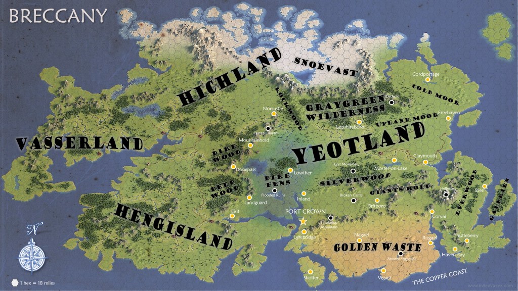
Together, Britain and Ireland are about 500 miles across and 550 miles high, which is 28 by 30 hexes, which is a good size for a map of a realm with four or five kingdoms and fits on a small hex page. If you want something the size of Europe and northern Africa for greater variety of climate, it will need to be more like 2000 miles by 1700 miles, so you might want a third map at a larger scale.
Step 2: Map the Mountains
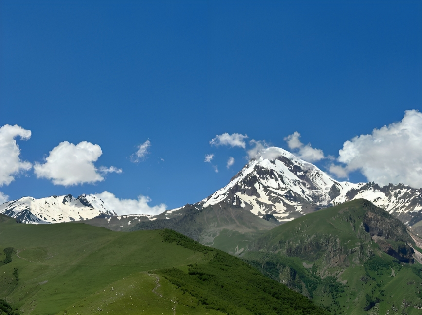
Next, look at real maps at roughly the scale of your map and copy a few mountain ranges. The beauty of doing this (rather than, say, imagining where tectonic plates come together) is that real-world mountains are well-documented. You can easily find height, vegetation, rivers, folklore, etc. You can even find photos of–and views from–them to use as visual aids or inspiration.
You might note the location of major roads thru your model mountain range to decide where mountain passes should be. Mark these, because they’ll be strategic to your realm and therefore get lonely fortresses.
Mountains may be forested (mostly with conifers) or–if particularly rocky or cold–treeless tundra. They tend to be dominated by dwarves, often in conflict with giants, ogres, trolls, goblins, and kobolds.
Step 3: Map the River Valleys
Use the location of your mountain ranges and examples from the real mountains to determine where the rivers come together to create river valleys. Start drawing a river in the hex where you decide it’s big enough to be difficult to cross; everything higher up is a tributary stream that’s easy to cross and doesn’t need to be on this map.
River valleys are famously very fertile land and so would be claimed by humans to clear for farming; in the Middle Ages, this means manors. Woodlands would be kept small and managed for human uses.
Step 4: Map the Wilderness
All the other types of terrain go in the areas that aren’t mountains or river valleys:
- Ancient forests on land that humans never managed to conquer or which isn’t fertile enough for humans to bother trying, such as those that are hilly and/or rocky. These are likely dominated by elves and treants, possibly in conflict with orcs, hobgoblins, and trolls. The trees are often huge and gnarled. Elves cultivate orchards and gardens to feed themselves.
- Young forests in areas that were once settled by humans but later abandoned due to war, disaster, or plague. They’ll therefore contain ruins on trails that are remnants of old roads. These are likely dominated by orcs, hobgoblins, and trolls, possibly in conflict with elves & druids. The trees are young and slim, with some areas being overgrown coppice stools.
- Hills, which may be wooded (wold), grassy (downs), or rocky and often feature caves. Goblins, kobolds, trolls, and ogres tend to live here, perhaps in conflict with humans and dwarves. This is a good place for a lonely manor specializing in grazing sheep. A depression often results in a mire (fen or bog).
- Moors, which are low, rolling hills covered in bushes like heather and gorse. They tend to be too acidic to support forests and farms but are good for grazing livestock. Altho wide open, there are occasional rock outcroppings and caves. Other depressions may become mires (fen or bog). Goblins tend to live here, often in conflict with humans.
- Lakes, marshes, and swamps, which are lowlands that fill with river water and overflow into other rivers or to the coast.
- Grassy plains (steppe), which are generally too arid for farming and/or lie too thin over rock to support woodlands, but which are good for grazing. Gnolls and centaurs tend to live here, often in conflict with humans and, possibly, huge beasts, like dinosaurs or mastodons. Trees tend to line rivers, and there are rocky ravines that hide caves.
- Deserts, which are very dry and usually sandy but sometimes rocky. If the climate was wetter long ago, there may be ancient ruins and tombs.
- Tundra, which is frozen grasslands and barrens in polar regions and mountainous highlands. If the climate was warmer long ago, there may be ancient ruins and tombs.
- Jungle, which is essentially hot, wet ancient forest. Exotic creatures may roam here.
Step 5: Map Major Cities
Major cities are 36 to 72 miles apart (2 to 4 hexes) in settled lands, situated on major rivers and lakes on the realm map. Roads tend to follow rivers, because smaller cities and towns are built along them. Therefore, you don’t actually need to map roads–you can just assume there’s a road between major cities along every river and in most places along the coast.
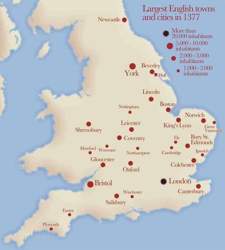
Roads would also, of course, lead to mountain passes, where trade ventures to neighboring territory. And major fortresses are often built in bottlenecks between bodies of water; since these tend to also be trade routes, they tend to grow into major cities. In the table below, note that England in the high Middle Ages only had 32 cities of at least 2000 people.
| Population | In 1377 England | Settlement |
|---|---|---|
| Manor (manor house and village) | ? | 75-150 |
| Market town | ? | 500-1500 |
| Small city | 19 | 2000-4000 |
| Major city | 12 | 4000-12,000 |
| Capital or center of commerce | 1 | 30,000-75,000 |
| Largest cities in the known world | — | 100,000+ |
Between major cities–along roads–are towns and small cities, mostly also along rivers and on lakes. In settled lands, there should be one small city in nearly every hex without a major city as well as a half dozen market towns. Don’t both to map these on the realm map, of course.

Places to adventure include:
- The Dire Fens, which were once diked, leaving rich, fertile land now dotted with flooded ruins and stalked by monstrous creatures.
- The Dire Wood and Deep Wood, ancient forests of Hengisland that spawn wretched monsters that invade Yeotland.
- Dread Caverns, endless caverns in the border mountains.
- Silverwood, a young birch forest amid ruins of settlements abandoned in the plague.
- Broken Castle, an abandoned castle on the moors, slighted in a war.
- The Graygreen Wilderness, an ancient forest dominated by monsters.
- Giants Hold and Hellgate, the ancient range and fortress of giants.
- Everwood, the ancient wilderness of elves and their perpetual enemies.
- Smoketop, the burbling volcano.
- The Golden Waste, an arid, grassy plain with some desert, once more fertile but now suited to camels, centaurs, and gnolls. But tombs of ancient kings are sometimes found.
Step 6: Map Some Local Areas
Create a separate map at a scale with 1-mile hexes to flesh out the area around your starting city, probably in a border land. This will be your exploration map, and you’ll eventually need one for each adventure location.
Typically, the heroes will travel across the realm map (at 1 hex per day, 2 if they have horses) and, when they reach their destination city, rest and resupply to venture off to the perilous ruins or caverns they decided to pursue. Travel on roads, which are safe and well-traveled, should use a simple encounter table where danger is rare. Travel on trails and across wilderness should use encounter tables for the particular type of terrain it’s in.
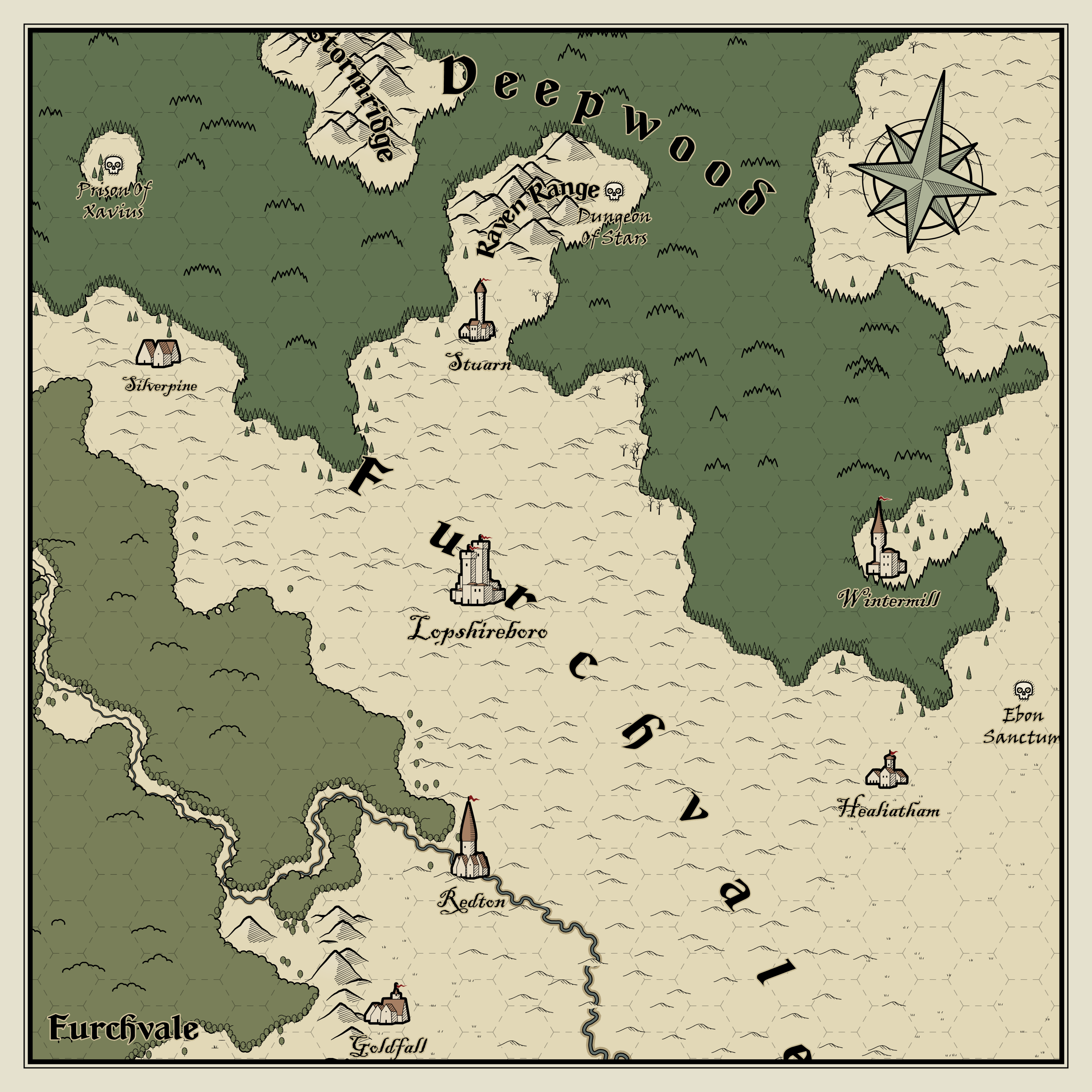
In the example above, we see the major city of Lopshireboro in Lopshire’s Furchvale. Adventurers might be tempted by the known perils of the Prison of Xavius, the Dungeon of Stars, or the Ebon Sanctum, or they may hear about some other adventure in the broadleaf forest in the southwest or stumble across some hidden peril while exploring the evergreen Deepwood.
As GM, you might say there are roads from Lopshireboro to Silverpine, Stuarn, Healiatham, and Redton (and points beyond), as well as a road thru the Deepwood from Healiatham to Wintermill. You might also say there is a trail from Silverpine to the Prison of Xavius but no trail that leads to the Ebon Sanctum on the lonely moor or to the Dungeon of Stars. If the heroes choose to go to the Dungeon of Stars, for example, they’ll need to explore the Deepwood or else pick their way thru the Raven Range–very different routes with very different encounters along the way.

Leave a comment